Changes in Great Salt Lake under observation after causeway breach
Officials are closely monitoring the impact the new breach in the Great Salt Lake causeway is having on the waterbody.
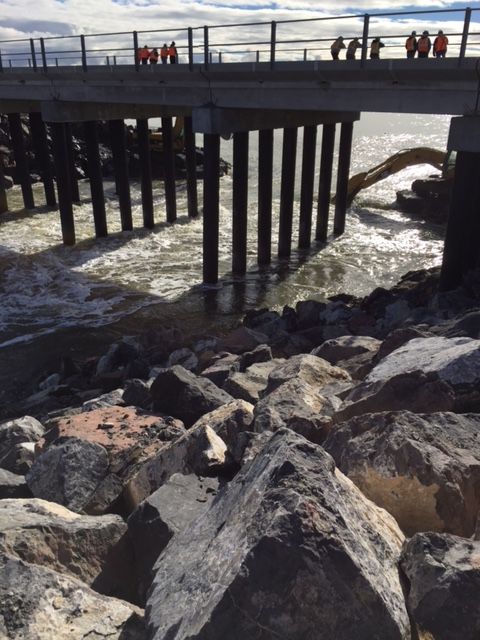
Union Pacific workers, with oversight from the Utah Department of Natural Resources, officially opened the causeway breach Dec. 1.
The day before, the lake’s north arm sat 3.5 feet lower than the south. The north arm was also salty to the point of saturation, virtually severed by the causeway from any freshwater inflows. But as water flows from south to north, a lot of unknowns remain.
“If we get a good runoff year, or a few higher moisture years, it might be OK,” said John Luft, the Great Salt Lake Ecosystem Program manager. “But right now, it’s overall, the lake is going to suffer due to the low elevations.”
Near-record low levels for the lake as a whole caused officials to delay the breach, which was originally scheduled for October. They had concerns about impacts to the south arm’s brine shrimp and birds. The north arm is way too salty for those species to thrive, and the south arm is approaching that salinity threshold.
READ MORE: LOSING THE GREAT SALT LAKE
The Standard-Examiner’s yearlong project about the environmental and economic consequences of a receding Great Salt Lake.
“Ideally, the window of salinity for brine shrimp to be productive is 12 to 15 percent, and we’re already over 16 percent,” Luft said of the south arm.
The breach delay concerned Ogden-based Compass Minerals, which has spent millions extending canals to reach evaporation ponds as north arm elevations continue to drop to historic lows.
With the breach pushed to Dec. 1, the brine shrimpers had a productive harvest, mostly due to warm temperatures and few storms through November, Luft said. Water is currently flowing north through the breach at a rate of 4,700 cubic feet per second — the Colorado River, by comparison, is currently flowing at 2,800 cfs. Water in the north arm is expected to rise by a foot over the next two to three months. All said, around 450,000 acre-feet of water will flow into the north arm.
That water exchange, however, will take a toll on the lake’s south arm.
“I think we will be approaching new historic lows,” said Cory Angeroth, a hydrologist with the U.S. Geological Survey.
The lake hit its record low of 4,191.35 feet in 1963, four years after the wooden trestle rail bridge was replaced with the rock-filled causeway, essentially dividing the lake. Union Pacific closed culverts that provided water flow in 2012 and 2013 due to structural concerns. Last winter, the north arm reached a new record low. Without a big winter snowpack, it’s likely the south arm will now do the same. As of Dec. 9, its elevation was 4192.3 feet.
“We’ll be really, right on the edge,” Luft said. “It’s going to have to be like a 2011 snow year for us. If it’s just average, we’ll hit an all-time low.”
Dropping lake levels are partly due to drought conditions in the region, but the biggest contributor is human consumption. Luft pointed to a recent Utah State University and Utah Division of Water Resources study that found the lake would be 11 feet higher if not for water diversions.
“We’re just using a lot more water,” he said. “The number of people has increased, we’re using more water for crops as well as human consumption. It’s kind of obvious that’s the major reason for the lower lake right now.”
Luft expects lowering water and rising salinity in the south arm to take its toll on brine shrimp in the coming years, who will spend more energy expelling salt from their systems and less energy feeding and reproducing.
“They’re not as salt tolerant as everyone thinks,” Luft said.
And while the new causeway breach means water can travel from south to north again, the lake will essentially remain two distinct waterbodies.
“We’ve got the vast majority of freshwater inflows into Great Salt Lake coming to the south arm, so the south arm will always be higher than the north,” Angeroth said.

Courtesy Union Pacific
The Union Pacific causeway across the Great Salt Lake was breached Dec. 1, 2016. Prior to the opening, water in the lake’s north arm sat around 3.5 feet lower than the south.
The Jordan, Bear and Weber rivers discharge into the south arm. Only a few seeps and springs reach the north arm. Angeroth said he’ll be monitoring discharge rates at the breach on a monthly basis.
“As we make more discharge measurements, we’ll have a better idea of how long it’s going to take for the arms to get to their final equilibrium,” he said.
Despite its complications and uncertainties, Luft said the causeway has altered the lake so dramatically that it’s currently a net benefit for industry and wildlife.
“It makes the south arm a lot more productive. I know that’s counter to what people have normally said – that the causeway is the lake’s problem,” he said. “If you didn’t have that there in the past, we probably would’ve seen a lot more volatility in the brine shrimp populations, and birds would’ve responded to that as well.”
Essentially, the causeway has taken the lake to a point of no return, he added.
“We’ve gotten to a point where it’s changed the north arm salinity so much, you can’t go back to the way it was without the causeway,” Luft said. “It would change the entire lake and not for the good.”
Contact Reporter Leia Larsen at 801-625-4289 or llarsen@standard.net. Follow her on Facebook.com/leiaoutside or on Twitter @LeiaLarsen.


